Elciego and around, cradle of Rioja wine

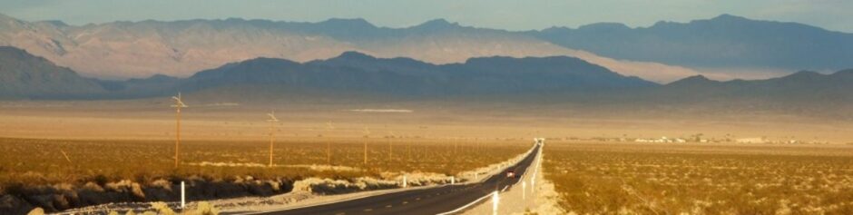
It’s the heart of the summer, and from the height south-bordering the Álava plain there lies at my feet, majestic and fertile, hot and glaring, the Ebro valley; namely the Basque side of Rioja, which is somehow a territorial inconsistence, since all southern Álava is, like Treviño, actually more Castilian than Basque; but we’re deep into an autonomic nonsense here in Spain, after Franco died.

Valle del Ebro al pie de la llanada Alavesa
The Ebro valey below the Álava plain

The road from Vitoria to the height descends now towards the valley in a series of fun bends which are a good challenge for a bike rider. Pity it gets so hot as I go down into the Iberic cauldron, the valley bed where the vinyards are, that I need to take my jacket off. Continue reading “Elciego and around, cradle of Rioja wine”

Treviño, a Castilian exclave in the Basque

Despite the many routes that I’ve already done around the Basque Country, I’m yet to see, in its southern part (called the Álava plain), something that does not resemble Castille; therefore I say: the fact that the Álava plain belongs to Euskadi and, worse yet, supports the Basque separatism, are things that remain beyond my understanding. Álava is historycally and culturally Castile.

But let’s start. Today I’ll take the bike for visiting the very polemic and disputed County of Treviño, which route belongs to the series The Basque Trail not for being part of Basque region, but precisely for being not: Treviño is a Castillian exclave within Álava, the anachronistic and symbolic last bastion that Burgos province is reluctant to lose. I invite the reader to make me company along this nice and interesting itinerary. Continue reading “Treviño, a Castilian exclave in the Basque”

The outermost Álava.

.
En el último capítulo de la serie Vasconia en dos ruedas castigué al lector con una soporífera ración de historia, y hoy quiero regalarlo con un episodio más pictórico y digerible: vamos a viajar en moto por una de las rutas paisajísticamente más hermosas y variadas de Vascongadas hasta el mismísimo confín de Álava, a su rincón más escondido, olvidado y remoto. Buscando el ocaso, pasaremos por la singular Añana y el plácido Espejo, llegaremos hasta Bóveda, allende las tierras de Burgos, y aún recorreremos unos quilómetros más para pisar el límite provincial, “donde da la vuelta el aire”.
¿Preparados?
El día está medio nublado, pero no lluvioso, y la temperatura es agradable. Salgo con Rosaura del centro de Vitoria en dirección Madrid y a los pocos quilómetros, en Nanclares, me aparto de la autovía por una carretera que esconde sorprendentes parajes y hermosos pueblos, de los cuales el menos desconocido es quizá Añana, por su peculiar (y casi único en España) valle salado, de cuyos acuíferos subterráneos, que atraviesan sedimentos salinos, afloran a la superficie salmueras (¡de 240 gramos por litro!) que durante más de mil años, y hasta época muy reciente, se han explotado para extraer su “oro blanco” por evaporación. Junto al pueblo, miles de plataformas o eras, canales, pozos y almacenes conforman el singular paisaje de este valle, si bien el cese de toda explotación a mediados del siglo pasado ha supuesto el rápido deterioro de las maderas y estructuras.

salinas
Valle salado de Añana

detalleSalinas
Detalle de las salinas, en proceso de recuperación.

Añana, topónimo de puro origen romano (que ahora quieren euskaldunizar por decreto anteponiéndole la palabra gesaltza, salina en vascuence), es una de las poblaciones más antiguas de Álava, que floreció gracias al mercadeo de la sal, un condimento de gran valor durante toda la edad media; y fue localidad castellana desde sus orígenes hasta el s. XVII, en que se incorporó administrativamente a la provincia de Álava; dato que tal vez deberían tener presente quienes reclaman independencia para el País Vasco por razones históricas (con frecuencia, como es el caso, más imaginarias que reales).
añana1
Añana desde la peña rocosa que la domina. Al fondo, los montes del confín de Álava.

Pero no han sido las salinas –por elevado que sea su valor etnográfico– lo que más me ha cautivado de este bonito pueblo, sino su entorno de pastos y arboledas, el caprichoso trazado de sus estrellas y pinas calles y, sobre todo, el romántico abandono de uno de sus más notables edificios, el palacio de los Zambrana-Herrán.
costadoPazo
Palacio de los Zambrana-Herrán, medio abandonado tras los muros de su huerto.

balconesPazo
Los tristes balcones del palacio, soñando con su juventud.

Son estas viejas construcciones de la añosa geografía rural española las que me invitan a la ensoñación y alimentan mi espíritu nostálgico, mi fantasía romántica, siempre mirando hacia atrás, hacia lo antiguo y pretérito. Tiene para mí el pasado un atractivo irresistible. El pasado digo, que no la historia.
callejuela2
Armoniosas y cuidadas calles de Añana.

En cuanto al entorno del pueblo, si bien se mira, lo menos bonito son precisamente las salinas. Lo mejor es el campo, las peñas, la arboleda.
añanaCarretera
Una franja de la carretera engullida por el paisaje.

Y por esa carretera que se pierde en el paisaje voy a seguir.
motoroad
La carretera hacia Castilla se zambulle en el paisaje.

Tras explorar a fondo Añana y sus alrededoes, continúo con la moto hasta Espejo, otro pueblo entrañable y encantador por su pequeñez, por el aire tradicional y el genuino sabor a viejo de sus casas, por la pequeña y anacrónica taberna, increíblemente estancada en el tiempo, que hay junto a la carretera, donde resulta imposible no detenerse a beber un chato de vino junto a los vecinos, ya entrados en años. En las paredes lucen antiguas fotografías y letreros enmarcados dignos de un museo.
fotografia
La Copa del Generalísimo 1954-1955. Toda una joya.

casaEspejo
Espejo. Hay una magia especial en la luz tras los cristales, un día gris y otoñal.

Not many things I enjoy so much as these outings back in time, that make me revive the days of my childhood, those bars in my home village with their wooden counters, the damp-dented walls, the old men playing cards on some wine-stained, vintaged table cloth…
Tomando un vino en el bar de Espejo.
Drinking a wine at Espejo’s bar.

But the best of this day is yet to come, when the road goes deeper into a groves landscape that brings forward to the eye the whole palette of autumn colours.
paletaclara
Palette of autumn colours.

We’re here between Castile and Basque country, the latter shaping a kind of peninsula inside the former, whose limits we cross two times. Formally, the last villages along this valley are Basque, but this is no Basque at all.
pinares
Tobillas village (Basque), under the pine woods and ridge bordering with Burgos province (Castile).

But before the hillock that makes the last geographical boundary, where Álava finally ends, we still find Bóveda, a village almost impeccable in its harmony with the country if it weren’t spoiled by some nonsensical, whimsical modern constructions.
 

Only five kilometres further, after crossing some quite peculiar rocky moorlands, the Basque country officially ends; from there on it’s Castile. This is the true outermost Álava, its remotest and most forgotten part. This is puerto de La Horca (Gallows pass), where the wind turns round.
motocima1
motocima3.
In the last chapter of my series The Basque trail I punished the readers with a dull share of History, and today I want to reward them with something more “pictorial and digestible”: let’s do one of the most beautiful and scenic bike routes in the Basque Country, to the very boundary of Álava, its most hidden, remote and forlorn corner. Heading the twilight, we’ll pass through singular Añana and tranquil Espejo, reach Bóveda, beyond Burgos province, and yet ride a few more kilometres until the boundary, “where the wind turns round”.
Ready?
It’s a cloudy, yet not rainy day, and temperature is fine. I take Rosaura, my bike, from downtown Vitoria direction to madrid for a few kilometres, then turn off by Nanclares, along a road that will take me through surprising settings and lovely villages, of which the less unknown is perhaps Añana, because of its peculiar (and almost unique in Spain) salt valley, whose subterranean aquifers, passing through salty sediments, well up brines (240 grams per litre!) that have been exploited during longer than one millennium, until quite recently, for extracting the “white gold” by evaporation. Right by the village, thousands of platforms or farms, channels, wells and stores shape this valley’s singular landscape, though the end of all activity by mid XXth century has meant a severe deterioration of the woodworks and structures.
salinas
Añana’s salt valley

detalleSalinas
Detail of the salt mines, now being recovered.

Añana, a pure Roman place name (now artificially changed into a Basque-friendly one by preceding it with gesaltza, meaning salt mine in Basque language), is one of the oldest settlements in Álava, and flourished thanks to the salt trade, a very valuable good along the whole middle ages; and it was a Castilian town since its very origin until XVIIth c., when it was assigned to Álava province; a piece of information that those who claim independence for the Basque country for “historical reasons” (more imaginary than real) should perhaps take into account.
añana1
Añana from its overlooking hill. In the background the outermost Álava.

Despite its ethnographic merit, though, it wasn’t the salt mines what most called my attention about this pretty village, but its milieu of sown fields and groves, the strange layout of its narrow and steep streets, and most of all the romantic neglect about one of its most fine buildings, the Zambrana-Herrán palace.
costadoPazo
Zambrana-Herrán place, half abandoned behind its garden’s walls.

balconesPazo
The sad balconies of the palace, dreaming of their youth.

These old buildings of aged rural Spain inspire my daydreaming and fuel my nostalgic spirit, my romantic fantasy, always looking back, towards former times. There’s something of irresistible in the pass, to me. And I mean the past, not the history.
callejuela2
Añana’s peaceful and looked after streets.

As to the environment, from an aesthetical point of view, it’s not the salt mines what I like the best, certainly, but the countryside, the hills, the groves…
añanaCarretera
A stripe of the road swallowed up by the landscape.

And that’s the road I’m going to follow, diving into the wild.
motoroad
The road towards Castile goes right through the landscape.

After fully exploring Añana and its surroundings on foot, I carry on with the bike towards Espejo, another endearing and snug village, with its traditional look and the genuine flavour of its houses, with that little and outdated tavern by the road, unbelievably stuck in time, where it’s almost impossible not to stop for a wine in the company of the locals, quite aged as well. On the bar walls, old photographs hung worthy of a spot in a museum.
fotografia
The Generalísimo (Franco) Cup 1954-1955. Quite a treasure.

casaEspejo
Espejo. There’s a special magic in the light behind the window panes on a gray autumn afternoon.

Pocas cosas disfruto tanto como estas incursiones hacia atrás en el tiempo que me hacen revivir los días de mi niñez, aquellos bares de mi pueblo, los mostradores de madera, las paredes desconchadas por la humedad, los viejos jugando al tute sobre algún tapete manchado de vino, en las mesas de formica…
Tomando un vino en el bar de Espejo.

Mas aún queda lo mejor de esta ruta, cuando la carretera se adentra en un paisaje de arboleda que ofrece, a cada golpe de vista, toda la extensa paleta de colores otoñales.
paletaclara
Paleta de colores otoñales.

Estamos a caballo entre Castilla y País Vasco, pues aquí Álava hace un istmo para engolfar por último a un puñado de minúsculas localidades. Administrativamente es Euskadi, pero esto no tiene ya nada de vascuence.
pinares
La aldea de Tobillas, bajo los pinares del risco que linda con Burgos.

Y antes del collado que hace de frontera geográfica, donde muere por fin Álava, nos encontramos con Bóveda, un pueblo que sería impecable en su armonía si no la hubiese estropeado cierta majadería arquitectónica de antojos modernistas.

Y cinco quilómetros más allá, atravesando unos páramos pedregosos de peculiar geología, acaba oficialmente Vascongadas y comienza Castilla. Este es el verdadero confín de Álava, el rincón más remoto y quizá olvidado de la provincia. Estamos en el puerto de La Horca. Con un poco de imaginación, aquí parece, glosando a Torrente Ballester, que da la vuelta el aire.
motocima1
motocima3
.

Orduña 2nd part ·

Juan de Garay, conqueror and colonizer, third governor of Río de la Plata, explorer of Paraná river and fouder of Santa Fé and Buenos Aires, was born in Orduña in the year 1528. But before this event took place, the borough was to know endless disputes and rows for the sake of its possession.
Thus I wrote upon cosing the first part of this chapter dedicated to Orduña and, apparently, thus it happened.
The first documented mentions of this settlement date from IXth century and place it as already existing by VIIIth C, when king Alfonso I endeavoured for populating the region. Orduña -it is said- always belonged to its own inhabitants, and could have been founded in the High Medieval times, perhaps by Christians fleeing from Muslim invasions. If this is true, we’d be facing an eminently Castilian foundation, therefore only slightly related to the kingdom of Navarra, not to mention a Basque Country which, strictly speaking, has never existed, in spite of many of its contemporary citizens). The first defensive wall encircling Orduña was so thick that two carts could cross on top.

One of the oldest streets in Orduña, leading to the ancient wall.

When trespassing this stone hall in the wall, if you close your eyes and adequately focus your senses, you can partake for a moment of the sensations of those who lived there millenniums ago; and even, with the help of some fantasy, you can hear the hustle and bustle of the old village: smiths hammering on their anvils, the bray of the donkeys, the hens clucking, the metalic noise of wheel rims on the cobbles, the peasants voicing their merchandise behind their barrows…

Opening in the original wall, revealing its width.


Notwithstanding Orduña’s ancient and seemingly autonomous origin, several centuries after its foundation it would lose forever (until recent times) its independence when king Fernando III, in 1218, granted to the Lord of Biscay, Lope Díaz II de Haro, the possession over the borough. The De Haro line, who weren’t lavish in names, christened their descendants with their father’s surname and, to the utter bewilderment and confusion of to-be historians, surnamed them with their father’s first name, thus forming a hereditary line worthy of some theatrical play. So, when the aforementioned Lope Díaz passed away, Orduña became his son’s, Diego López III de Haro, who in 1229 granted the village the same privileges as those of Vitoria (which served as a reference in such times and lands) and whom, upon ascending Alfonso X the Wise to the throne, gave up his serfdom to the Castilian monarch and went under the king of Navarra; though, willing to withhold by force what was given to his father as a grace, the Castilian troops had to suffocate the upraisal and recover Orduña.

Some of the new streets after the expansion. The mountains in the background.

Later on, by mid XIIIth C., Alfonso X himself authorized an enlargement of Orduña by six new streets, granted it royal privileges, different from the lordly ones it had, and gives them the monopoly over the commerce, thus acknowledging and promoting the growth in market and population that the village was experiencing.
XIIIth century was not gone when the Lords of Biscay (by then, Lope Díaz III de Haro, not to be mistaken with Diego López III, his father) return to disputes and set out their complaints to the Castilian king, who sentences like this “and about what thou say that Orduña must be yours and it was given by king Fernando as a grace to Don Lope and Doña Urraca your grandparents, truth is; but thou has made war from there and from there caused severe harm on earth, and privilege of Castile is that, if war is made from what was given by grace, and harm is done on earth, then Castile can take it righteously by force”, thus denying him the lordship he claimed. But after this king’s death, Lope Díaz III sook the suppport of Sancho IV (who was struggling with his nephews for the Crown) and made fast his power in Orduña and surroundings, granting it “entilement state of Biscay”.

Imposing flank of church-fortress of Santat María.

Of course things were not to remain like that: once Lope Díaz passes away, the king Sancho IV recovers Orduña and, to reinforce such posession and to congratiate himself with its population, Sancho grants a new privilege to Orduña: an annual fortnight fair. By then a new, more ample wall is built, and the old one gets partly embedded in the church of Santa María. It is indeed stunning to walk around the church, more alike a fortress, and to watch upwards to its tall buttresses, its warlike patrol walkway and its sturdy impregnable walls.

Close up of the patrol walkway encircling the church of Sta. María.

Yet, Orduña’s misadventures had but begun. Taking advantage of Fernado IV’s minority, a new De Haro comes into play: he’s Diego López V, brother to the deceased Lope Díaz III, and he confirms the entailment state of Orduña subjected to the Lords of Biscay; but when he himself dies leaving no descendants, Orduña seizes the occasion for going back to the Crown of Castile, for the fourth time now; though not for too long: while dinastic struggles are held between Pedro I and Enrique de Trastámara, the latter delivers Orduña to his brother Tello, the actual Lord of Biscay. And though by 1370, after Tello’s death, the very lordship of Biscay is held by the king himself, Juan I of Castile, years later his heir Enrique IV confirms the privileges of Orduña and gives it back to the Lords of Biscay, who were now the Ayalas; besides, he exempts the village of paying taxes to the powerful Castilian stock societies and, finally, he grants Orduña the title of city in 1467, thus becoming the first and only population of Biscay with such a status.

Dreadful legend under Sta. María’s portico: “To death a judgement must follow, a veredict eternal: either everlasting glory, or a hell everlasting”.

And here we are, dealing again with the ambitious house of Ayala, which we’ve already seen lording over boroughs and towns in other chapters of this series. The Ayalas first won a lawsuit concerning the posession of some of Orduña’s hamlets, with the help of Valladolid’s Chancery, and then the marshal García de Ayala gains from king Enrique IV the positon of Justice of Orduña; nomination that was later revoked by the Catholic Monarchs in 1476, not without violence, because Ayala didn’t accept such decision and was to be fought against. Four years later, among other several provisions on Orduña’s behalf, the Monarchs ratified that the city would never again be parted with the Crown, nor its posession given away, they also revoked any mercy of Orduña granted to the Ayalas and granted its defense and its hamlets’ against the marshall and his son, who continued keeping the mayoralty of the castle; and these two, though being forgiven the uproars when trying to get hold of Orduña, they were commanded to pay a high sum “for the evil it had got by their cause”.

Colourful bar street.

Meanwhile all these ups and downs took place, Orduña had experienced a second expansion thanks to the commercial situation derived by the increase in merchandise contracted between Castile and the Cantabric harbours: once more the city walls were broadened, encircling now the market square; however, when all struggles for the Orduña’s posession seemed to be settled, along with an economical prosperity without uproars, in 1535 part of the city was destroyed by a fire, and its importance declined in the region. Worth mentioning is the customs building, outstanding for its architecture, soundness and situation; built in 1793 costed three millon reales.

This is not the customs building, but the city hall, which is nicer.

As anyone can see, Orduña’s history has little to no connection with Navarre or Basque Country. Its recent basquism is only a matter of political interests (which are, after all, economical interests). But what’s more important yet: anyone can see how absurd is to maintain nowadays privileges whose goal disappeared centuries ago: they were decreed for stimulating population of certain regions and, once this was achieved, the privileges lose all sense; worse yet: keeping them today implies an unfair discrimination against the rest of Spanish regions.
And now, reader, if you’ve stood fast this far, following me along the meanders of Orduña’s history, its repeated and mingled stages, the ceaseless serfdom shifts, I’m sure you won’t mind if I guide you along the other meanders: those bends of the road that take us to its beautiful surroundings, most of all if you’re a motorcycler fond of bends and landscapes; because Orduña enjoys a privileged scenic situation, right in the middle of a wide oval valley, fertile and splendid (as the historian Madoz put it), among high and precipitous hills of a unique natural beauty.

Old house-mill in the outskirts of town.

First, taking a stroll along town, we can find this lovely corner that seems to be anchored in the past; this huge ramshackle house that was perhaps a mill -as it’s erected by a stream- or maybe a guest house, or a farm, and which now looks neglected, inhabited only maybe by ghosts of our great-grandparents’ times.

Close up of some windows opened in the house’s wall.

These windows are also an example of the austere and practical architecture of yore, when people lived mostly in the open and bedrooms were for just sleeping, thus light not being particularly appreciated.

School Compañía de María.

This one is just a nostalgic shot for me, totally meaningless for you: a school of the Compañía de María, a nuns’ order ruling many educational centers in the past century. My sisters used to attend to one back there in our early childhood, when time didn’t exist at all, and the skies always shined a whitish blue, with that special light of the cities in the south, by the sea; a light that forced me to always keep my eyelids halfway closed.
Once out of town, if we keep riding south along the same road we came in, we soon start climbing the steep slopes and U bends going up, up the almost vertical hill of Sierra Salvada until, once upon the summit, we arrive to the province of Burgos. From up here you can behold the most scenic view of all: the green fertile and handsome valley of river Nervión where the founders of Orduña laid their craddle, a treasure coveted by endless kings and lords one after another for generations; sheltered, temperate and fruitful, where such wines are elaborated that may well outstand those in France…

As the evening comes in, the valley gets half in the shadows of Sierra Salvada’s peaks.
Waterfall, one of the park’s highlights. Burgos pours its waters on Biscay, fertilizing it.

What now remains to be said? We’ve been together along the best of Orduña: the roads, the landscapes, the history, the streets. It’s time for a farewell á la Rosaura (my motorcycle): some good pinchos and a superb wine, of the local kind called chacolí.

This pincho, Orduña patent, was awarded a price in the 2012 contest. Absolutely delicious!

That’s all, folks!

Orduña (1st part) ·

Of course, the city of Orduña didn’t need this chapter in my series The Basque trail for being well known in the country, as its beauty, along with its landscape diversity, and even its climate, by their own right play an outstanding role in this part of Spain. But then, a travel journal about the Basque Country wouldn’t be complete without the Orduña route.
Indeed, as was written by the Spanish geographer Madoz around 1840: seven leagues away from Bilbao and six from Vitoria, Orduña is the only city in the province of Biscay. It’s placed on the flat slope of La Peña, where a grassland spreads out 3/4 of a league’s wide and 5/4 long, splendid, fertile and beautiful; climate is mild and very healthy, and most common diseases are rheumatism and common cold[…] Among others, chacolí wine is produced which could outdo that from Bordeaux, if only it were better elaborated. I don’t know how Orduña chacolís were by 1840, but nowadays’ Bordeaux must needs be quite good for not being outdone by ours: as I’ve had the chance of learning along my little trip, extremely tasty wines are fermented in this city. As my readers (if there’s any) already know, wine always plays a main role in my rides… up to where the traffic law allows me.
But let’s kick start, because we’re about to begin one of the finest motorcycle journeys you can take in the Basque region: same the road to Orduña as the city itself, and its surroundings, are good from start to finish. Exiting Vitoria by route N-622, we’ll leave the double laned highway at Izarra, hence taking the bucolic local road A-2521, where the true route begins through invigorating natural settings.

postekm
Artistic milestone under the oaks’ overseeing shades

Little far from the aforementioned junction I pass through a shady and damp grove of oaks and ferns, inviting to get into it for the search of goblins and leyends. Someone, in those times where things were made to last, marked out the road with worthy handcrafted milestones like this in the picture. Yet a little further, past the grove, among fertile prairies some hamlets lie, specking with terracotta shades the greenish colours of the sunny basin. I make a halt in one of them, maybe Goluri, where I park the bike and take a stroll for making some pictures. Behind the church, the peasants have built a fine bolategui (a long sheltered board lane for playing a typical Basque ball game), along whose side they pile wood for warming up their games and gatherings during the long winter months.

leñabolategui
Goyuri’s Bolategui
bolategui
Bolategui inside

A mile further, the ancient tower of a solitary chapel by the road, outstanding the treetops, makes me stop again. Since my youth, the retreat of these lonely shrines or hermitages has always awakened my emotions, and it’s but with reverence that I approach or contemplate them. By its northern side there is a small graveyard with the tombs, I reckon, of the valley inhabitants who worked its land and chopped down its trees. Requiescant in pace.

ermita
Goluri’s shrine, nearby the road
cementerio
Graveyard behind Goluri’s shrine

Cottages or chapels, though, aren’t the only treasures to be found by the traveler heading for Orduña, but also breathtaking landscapes suddenly coming out behind a turn of the road. Thus, after the last stretch of pavement cuts those prairies like a knife, past a bend there appears the superb, astounding rocky walls of the valley where the Nervión river springs, and on whose bed rises the city we’ve come to visit. Along the ridge of those mountains lies the border dividing Biscay from Burgos.

Valle alto del Nervión. Al otro lado está Burgos.
Nervión’s upper valley. Burgos beyond the mountains.

The sharp cuts made on the rock by the ice, millions of years ago, forming the upper valley of the Nervión, disappear in the distance.

Valle glaciar del Nervión.
Nervión’s glaciel valley.

Now it’s time for having some fun with the motorcycle: here the descent starts along sharp bends of the road taking us to the valley bed, and rounding off with a beautifully balanced final stretch, lined by trees, which leads into Orduña.

Arbolada recta de llegada a Orduña.
Tree flanked stretch leading into Orduña.

Our first sight of the city: the robust and warlike profile of Saint Mary’s church-fortress, which once integrated the walls fending Orduña off its enemies along the many fights in its history.

Iglesia-fortaleza de Santa María.
Saint Mary’s church-fortress of the warlike built.